All links on this webpage open in a new window or tab.
An online map of the route for walking from St Albans City station to St Albans Abbey station is available here route for walking . All links on this webpage open in a new window or tab.
The most straightforward route to navigate is via the City centre. By moving upwards on the online map, this is along Victoria Street to the City centre then turning left down Holywell Hill. For a fit person, it would be best to allow at least half an hour. In the other direction this involves walking up Holywell Hill, which is steep. It is also possible to walk via minor roads.
We will now outline alternatives which should be more pleasant. All alternatives make use of the Alban Way which is not lit after dark. All photos are courtesy of Google street view and open in a new window or tab.
From the map as it was prior to moving upwards, or by clicking again on the link above, all alternatives are by walking southwards from the City station and then walking along the Alban Way, which is the route of the former St Albans Abbey to Hatfield line. To walk southwards from the City station there are two alternatives, either on the west or on the east of the Midland Main Line (MML). Let us outline the first of these two, on the west of the Midland Main Line (MML). By use of the station footbridge if necessary, leaving the station by the platform 4 exit and turning south along Ridgmont Road, with St Albans South signal box museum on your left, then through some bollards one continues along Ridgmont Road. Bearing left into Grosvenor Road one continues until it meets London Road at a roundabout. The aim is to cross to the road opposite, there being a means to cross the busy London Road a short distance to your right, which can be viewed by zooming in on the map. Returning and then along Orient Close which bears left, one arrives at a T-junction, also Orient Close. These are lightly used roads. The former London Road station is on your left. Turning right along Orient Close, this becomes the Alban Way footpath and cycle track. By continuing along this, further details later including, at the time of writing, an incorrect sign at Sadleir Road, passing beneath Cottonmill Lane passing beneath Cottonmill Lane one arrives at a pedestrian T-junction.
At this pedestrian T-junction, it is possible to turn right as signposted for the Abbey station, walking alongside Cottonmill Lane, crossing Jenny Lane and Leyland Avenue. Unfortunately, at the time of writing, there is an issue with the signs at Leyland Avenue. The sign for the Abbey station is pointing in the wrong direction and should be ignored Junction Cottonmill Lane and Leyland Avenue and Junction Cottonmill Lane and Leyland Avenue (detail)
(For those walking in the opposite direction from Prospect Road along Cottonmill Lane, with Mentmore Road on your left and crossing Leyland Avenue, the path for the City station is on your right Mentmore Road on your left and crossing Leyland Avenue and Mentmore Road on your left and crossing Leyland Avenue (detail) . It would be helpful if the sign to the Alban Way, photo in previous paragraph, also indicated this is the route to the City station. )
Ignoring the sign pointing in the wrong direction, by crossing Leyland Avenue and continuing along Cottonmill Lane to the mini-roundabout, then along Prospect Road until the end, turning left at the main road, one arrives at the Abbey station Abbey station entrance and Abbey station sign and Abbey line list of stations
Although not signposted, there is an alternative by turning left at the pedestrian T-junction and using the foot crossing to cross the Abbey line, turning right on a footpath and cycle track alongside Griffiths Way with Sainsbury's on your right. From Griffiths Way there is a view of the Abbey line across the Sainsbury's car park, the houses being on the other side of the line The Abbey line viewed from Griffiths Way . Continuing along this road, by turning right at the main road, the station is on your right. The corner can be cut off by crossing Everard Close from Griffiths Way and then along it, then left into Abbey View, then beside the entrance to the underground car park. There are then some steps leading to the main road where turning right the station is on your right.
Now let us describe the route that is, of all these, considered to be the most traffic-free. This is by walking southwards from the City station and on the east of the Midland Main Line. Leaving the station, this time by the main exit, with bus stops in front of you, turn right beneath B691 Victoria Street which is on the right in this photo beneath Victoria Street . Following the footpath the main line is on your right. Lightly-used Charrington Place is on your left with a crossing which can be viewed by zooming in on the map. Turn left onto the crossing onto the Charrington Place crossing and then right off the crossing to continue on the other side of Charrington Place leaving the Charrington Place crossing . Continuing beside Charrington Place until the mini-roundabout, bear left past iMed Pharmacy and Hatfield Road Surgery, take the path on a slight downhill slope with apartments on either side rather than following the road.
(For those walking in the opposite direction, at the head of this path, bear right to walk beside Charrington Place path between Charrington Place apartments )
The path leads to a back-and-forth zig-zag path descending to the Alban Way. Photo at the top Top of path between Charrington Place and the Alban Way and at the foot Foot of path between Charrington Place and the Alban Way . This path includes some barriers intended to encourage cyclists to dismount and may be unsuitable for wheelchairs. Descending the back-and-forth zig-zag path one arrives at the Alban Way. By turning right on the Alban way, also marked St Albans Green Ring, and walking along it, an impressive single-arch bridge carries the Midland Main Line overhead. Shortly after this is a mundane bridge carrying London Road overhead. The Alban Way becomes a footpath alongside Orient Close with a view of the former London Road station view westwards of former London Road station . One then walks past the platform of the former London Road station: the Alban Way is the route of the former St Albans Abbey to Hatfield line.(For those walking in the opposite direction, view eastwards of former London Road station and view eastwards of London Road bridge .)
The Alban Way leaves Orient Way passing between two houses passing between houses to become rural. The next event is crossing the River Ver crossing the River VerThe next event occurs with Sadleir Road on the right. During some construction work the route for walking to the Abbey station was diverted along Sadleir Road and Mentmore Road. This is still available but it is more straightforward to stay on the Alban Way. If the sign indicating a diversion along Sadleir Road has not yet been removed, it can be ignored. The sign could or can be seen in this view from Sadleir Road End of Sadleir Road
Ignoring this sign, if still present, and proceeding along the Alban Way one passes beneath Cottonmill Lane passing beneath Cottonmill Lane , photo also earlier, to arrive at the T-junction as earlier where it is possible to turn right or left.
In passing, as it were, it is possible to walk or cycle on the Alban Way all the way to Hatfield, reference https://en.wikipedia.org/wiki/Alban_Way and with external links that include photos of the MML single-arch bridge.
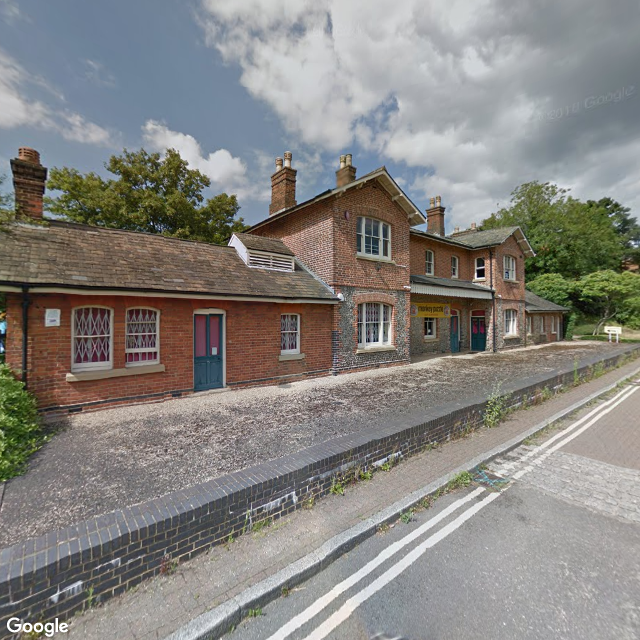
Here is a photo of the former London Road station and now in private use as a day nursery and preschool.
For those walking in the opposite direction from St Albans Abbey station to St Albans City station, information specific to this is included above (in brackets).
Walking exercise: can you find this sign? (opens in a new window or tab).
For the journey between St Albans City and St Albans Abbey stations by bus, information is available at intalink.org.uk
Disclaimer: no responsibility is accepted for use of any information that may be provided.
AbbeyRail home page home page
Last revised 8 January 2025