Publication date 24 March 2022
Revised 19 June 2026
This is part four of our review into travel by rail in the Oxford to Cambridge arc.
As also in part three, much of our focus will be on the Abbey line. This is a single-track line, permitting a train either in the direction Watford Junction to St Albans Abbey or in the opposite direction but not both at the same time. Indeed the current service is provided by a single train.
It is recommended to read the home page and then to read part three, starting at the section "Impact on the Alban Way" Impact on the Alban Way through to the end, prior to reading this part, part four.
A full set of links to sections in part three is available on the railenable.com home page.
It is recommended to read this part from section "Connecting the Abbey line to Watford High Street" to the end.
All four parts can be accessed via List of articles
A direct link between Watford Junction and St Albans City would have been achievable by reopening the dismantled rail link north east from How Wood to the Midland Main Line for St Albans City. Known as the link at Napsbury, illustrated as a red line below, it is now obstructed by Radlett Strategic Rail Freight Interchange (SRFI) or freight terminal.
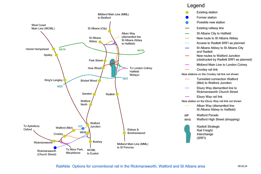
In this photo, prior to construction of the freight terminal, How Wood station is lower left, the Midland Main Line is on the right, the former link north east from the station now being wooded north-east-from-How-Wood
An online map is available here (opens in new window or tab) Source : openstreetmap.org © OpenStreetMap contributors
Reopening the dismantled link would have required rebuilding the former bridge over the A5183, for which one of the buttresses of the former bridge still exists A5183-bridge-buttress . Housing known as The Beeches was built to permit reopening of the link without being disruptive: access would have been beneath a bridge the-beeches . This would have provided a single track link although this would reasonably have become dual track across the site of the former Radlett airfield being the site of the freight terminal.
To facilitate operations it would have been reasonable to provide an in-station passing loop at How Wood station.
Later we will consider the possibility of a light rail link from Watford Junction to terminus platforms at St Albans City.
This section is historical since a direct link between Watford Junction and London Colney, illustrated as a red line in the previous section, is obstructed by Radlett freight terminal.
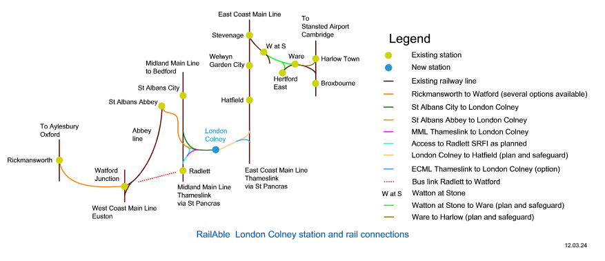
A railway station at London Colney is introduced in the later section "Railway station at London Colney". This is not affected by Radlett freight terminal.
If Radlett freight terminal had not proceeded, Watford Junction to London Colney would seem to have been a realistic proposal. A train passing facility at How Wood would dovetail in with this, with a centrally-located island platform pair between the tracks. North of here, the western-most track would be for trains to St Albans Abbey, the eastern-most track for trains to London Colney. There would reasonably be a pair of crossovers enabling trains to St Albans Abbey and to London Colney from the western platform and trains from St Albans Abbey and from London Colney at the eastern platform.
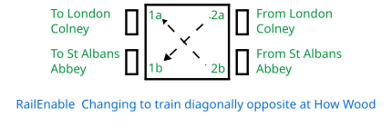
There could have been potential to trial Digital Automatic Coupling (DAC) at How Wood. Currently in use for freight trains it is also thought to be in limited use for passenger trains, although not in the UK, to our knowledge. A train from Watford would divide to form a train to St Albans Abbey and a train to London Colney. In the reverse direction, a train from St Albans Abbey and a train from London Colney would be attached. Passengers between St Albans Abbey and London Colney would change at How Wood. There would seem to be two potential arrangements, illustrated below.
In the first arrangement, passengers change trains to the train diagonally opposite:
In the second arrangement, passengers change trains to the train directly opposite:
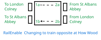
The journey time from How Wood to Colney Fields Shopping Park would be approximately the same as from How Wood to the Abbey station.
We are proposing Watford Junction to London Colney via St Albans Abbey where trains change direction.
We are proposing a railway station at London Colney. There would be a service from London Colney on the Midland Main Line (MML) to St Pancras International for continental rail services, Central London and Gatwick Airport.
Drawings (diagrammatic maps) are displayed full size for clarity.
There would be a rail link to Watford Junction. This might be a conventional rail link with trains to St Albans Abbey and intermediate stations terminating at Watford Junction, possibly continuing to Euston. There is the alternative option of light rail, as for conventional rail but extended to Watford High Street and a new station Watford Hospital. The light rail option is documented on the hertsrail.org.uk home page with additional detail later in section "Connecting the Abbey line to Watford High Street".
A railway line eastwards to Hatfield would reasonably be planned and safeguarded.
It is likely that an interchange will be needed at London Colney between a local service from Watford and the Midland Main Line (MML) service. How might London Colney station be designed to permit an interchange by crossing from one platform to another without having to use a bridge or tunnel between the platforms? One possibility would be for through services to call at a central island platform pair which has one or two bay platforms built into it. Interchange on the level is achieved by passing the end of the bay platforms, however passenger flows have to be considered. It would seem reasonable to provide a well-signposted interchange by means of a bridge or tunnel, with the option of passing the end of the bay platforms suitably sign-posted e.g. for persons of reduced mobility.
The following map shows the existing railway lines and stations around Watford. The station labelled Watford is also known as Watford (Met). It is the terminus of the Metropolitan Line branch to Watford. In a north easterly direction from Watford Junction is the Abbey line to St Albans Abbey. Click the map for Wikimedia information.

The following map shows the envisaged route of the Metropolitan Line Extension (MLX). This was formerly known as the Croxley Rail Link, being terminology that we still employ. This time, the Abbey line is absent from the map.
The Metropolitan Line Extension, also or formerly known as the Croxley Rail Link, extends the Metropolitan Line via Croxley to Watford Junction. The Croxley Rail Link is oriented south west from Watford High Street making use of the start of a dismantled rail link to a former station Rickmansworth Church Street, not shown, and then turns north west, on a dismantled branch. It then requires a connection onto the existing Metropolitan line branch via Croxley currently terminating at Watford (Met).
There is a triangular junction between Rickmansworth, Croxley and Moor Park. The chord between Rickmansworth and Croxley at this junction is known as the Watford North curve, albeit not in the vicinity of Watford North station on the Abbey line. The Watford North curve enables Rickmansworth to Watford Junction. Click the map for Wikimedia information.

As an alternative to the Croxley rail link, there could be a tunnelled connection from Watford (Met) to Watford North on the Abbey line via Watford Junction, whilst retaining the connection from the Abbey line onto the WCML. An intermediate station Watford Parade (or Watford Pond?) would be provided between Watford (Met) and Watford Junction. A tunnelled connection would not enable an extension of London Overground (Lioness line) services i.e. via Bushey on to the Abbey line to St Albans Abbey. An extension of Metropolitan line services on to the Abbey line would be possible or, at the least, to Watford Junction. The Croxley rail link was planned to enable Metropolitan line services to Watford Junction but with the loss of Watford (Met) station. This alternative brings Metropolitan line services to Watford Junction whilst retaining Watford (Met).
Another alternative to the Croxley rail link could be an Ebury Way rail link, coloured in purple above. The Ebury Way from Watford High Street to Rickmansworth is shown at https://www.openstreetmap.org/#map=16/51.6489/-0.4007 and at https://www.openstreetmap.org/#map=16/51.6411/-0.4328
With reference to the second of these openstreetmap.org links, Croxley Common Moor is shown. Google provides a view from high up on Croxley Common Moor. On the left is the Ebury Way alongside the built-up area. By zooming in further to the right, there is the railway line to Rickmansworth. An Ebury Way rail link from the Ebury Way on to the railway line to Rickmansworth could be constructed in this location:
Croxley Common Moor as a static image Croxley Common Moor (photo opens in a new window or tab).
Railway line to Rickmansworth as a static image Railway line to Rickmansworth (photo opens in a new window or tab).
Returning to the Croxley rail link as originally planned, a crossing could be envisaged over or under the WCML at Watford connecting Watford High Street to the Abbey line via Watford Junction although this was not part of the plan. This is discussed in a later section "Connecting the Abbey line to Watford High Street".
There have been persistent issues regarding funding of the Metropolitan Line Extension (MLX). In June 2021 Steer published the document "Metropolitan Line Extension
Alternatives" ( Referenced papers and reports (opens in new window or tab)).
On pages 30 and 31 of this document
"Croxley rail link :
2.54 The original Metropolitan Line Extension (MLX) would have included the use of the former Croxley Branch Line,
which is currently owned by Network Rail under the London and North Western Railway Act 1907. The MLX would have involved
the construction of a viaduct over the Grand Union Canal, River Gade and A412 road. The need to build a viaduct to connect the line
to the proposed Cassiobridge and Watford Vicarage Road stations is a constraint, as it was a key cause of the scheme’s unaffordability,
as well as the signalling costs associated with the compatibility between the underground and rail systems.
2.55 There is an opportunity to include the disused alignment in alternative options, which will be considered in this study."
On page 109
"9.1 The MLX delivers best against the local and strategic connectivity scheme objectives and, in this respect, is the best performing
of all the options considered. However, the affordability issues are such that there is no realistic prospect of the MLX scheme being
progressed in the near or medium-term."
On page 122
"10.4 As such, the study has concluded that no alternative meets the project objectives as well as the former MLX scheme did,
which was discontinued due to affordability reasons."
So, in terms of meeting project objectives, the best option is to proceed with the former MLX scheme, but with a question of affordability. Whilst rail costs are too high, albeit a matter not discussed here, there is the opportunity to render MLX more affordable by combining it with the aspiration of a Aylesbury - Watford rail corridor. In part three section "Outline business case for a St Albans to Hatfield railway" we outline the business case for a St Albans to Hatfield rail corridor. Towards the end of that section we suggest assessing MLX and Aylesbury - Watford as a single project. Since no such assessment has taken place, MLX should not be regarded as dead.
In passing, we take the opportunity to note that Aylesbury - Watford without MLE would merit evaluation since this offers the opportunity to reduce capital costs by avoiding the signalling costs associated with compatibility between underground and rail systems.
On page 53 table 6.2 there is indeed the objective of "Sustainable connectivity to the West (Rickmansworth / Amersham / Aylesbury)" however this has not been assessed as a single project with MLX.
On page 48 section 6.5 "One objective will be to provide a viable alternative to private car-based travel on the congested A412 route." Our proposal for east west rail in Hertfordshire certainly does that.
Let us now turn to the matter of Mass Rapid Transit (MRT). On page 79
"Description of Mass Rapid Transit in the MLX Alternatives Context.
Mass Rapid Transit (MRT) is a generic description to describe high-quality rubber-tyred transit options. These cover a spectrum of vehicles
ranging from a high-quality conventional bus (low floor, low emission) to vehicles similar in specification to trams."
Trams or tram-trains, i.e. running on rails, are separated out in this document into the preceding section (pages 77-79), with an overall summary
"Significant deliverability and affordability risks". This is a different approach from the A414 corridor strategy technical report
(
Referenced papers and reports (opens in new window or tab)) where Mass Rapid Transit is defined as
"A public transport service including bus, tram or similar which carries multiple passengers on a prioritised route.
A bus rapid transit is a form of Mass Rapid Transit." (page 75).
Returning to the Metropolitan Line Extension Alternatives document, on page 116
"9.40 The A414 is a dualled road running from the A41 west of Hemel Hempstead all the way to Chelmsford. This road is characterised by high congestion levels.
9.41 However, the A414 is the key route between Watford – St Albans and Welwyn and has been identified by HCC as a potential route for MRT."
This identifies a design flaw in the MRT proposal. There is no proposal for MRT vehicles to be routed anywhere other than via the A414. As a result, either the A414 is downgraded to permit MRT vehicles to run on a dedicated bus lane, in which case congestion on the A414 is likely to increase, or they share the A414 with other vehicles. In the second case, they are likely to be subject to delay due to congestion, resulting in the entire MRT project being at risk of failure. We will return to this later in section "HERT converts the Abbey line to a busway".
There are three options for Mass Rapid Transit (MRT) in terms of routing through Watford town centre. All three envisage MRT vehicles to Watford Junction via Clarendon Road. They are illustrated on pages 82, 85 and 88, noting the annotation "St Albans Extensions". This confirms conversion of the Abbey line to a MRT/busway requires MRT vehicles to take over the underpass from Station Road to the car parks, rendering the car parks inaccessible and therefore triggering redevelopment of Watford Junction. It is sad to note that redevelopment of the station is presented as an opportunity to capitalise on the commercial value of the site, the real reason being to enable MRT vehicles to cross the main line. The true costs of the MRT project are therefore being disguised. This point is noted in part three section "A review of Hertfordshire - Essex Rapid Transit (HERT)" in our response referenced there to the HERT public engagement November 2021 - January 2022.
When (i) there has been no assessment of MLX and Aylesbury - Watford as a single project and when (ii) the true costs of the MRT project and of HERT are being disguised, it is clear that the Croxley Rail Link should not be regarded as dead.
Some additional comments on the document follow.
Hertfordshire County Council policy towards the Abbey line is reproduced on page 45
"5.10 The position of HCC is that it supports the continued use of the Abbey Line as a heavy rail operation, whilst seeking improvements that would
increase service frequencies. HCC would consider longer-term options if these were to enhance connectivity for the line."
Since this was quoted, there is now a published plan to close the Abbey line, section "HERT converts the Abbey line to a busway".
Pages 66 to 68 discuss Underground Option 2 – Metropolitan Line Extension to Watford Junction via tunnel. Key infrastructure would include a new underground station at Watford Junction, and potentially also in Watford Town Centre. This is the tunnelled connection we discussed earlier, as originally hypothesised in part two of our research.
The document "Metropolitan Line Extension Alternatives" published by Steer is also referenced in the section "Connecting the Abbey line to Watford High Street".
This section is historical. Those who are skim-reading may wish to pass over this section.
As from March 2024, Hertfordshire County Council refers to rubber-tyred "trackless trams", reference provided in the next section "HERT converts the Abbey line to a busway". We refer to trams here as rail-based vehicles.
As from March 2023 this section is historical. There is no longer any claim that HERT might be implemented as trams i.e. rail-based. The claim has been superseded. Updated information is in section "HERT converts the Abbey line to a busway". There seems to no longer be any reference to an east-west tramway on the Hertford Civic Society home page.
As noted in part three, a downgrade of the A405 between Watford and St Albans is planned with reallocation of 1 lane in each direction to buses only. This enables buses to compete with the Abbey line, the competition leading to closure of the line. As noted in part three section "The Abbey line is being undermined", from this we know that MRT vehicles will be rubber-tyred buses and not light rail trams, since trams require rails and no-one would propose rails along the A405 to be superseded by use of the Abbey line.
However, the A414 corridor strategy technical report ( Referenced papers and reports (opens in new window or tab)) claims that the choice between rubber-tyred vehicles and trams has not been made. There are illustrations of trams on page 57.
In these circumstances it is reasonable to suggest that HERT is based on an illusion but with an outstanding question : on what foundation is the illusion based ? There was a proposal for an east-west tramway in south Hertfordshire from Watford to Hertford/Broxbourne. The proposal was by Hertford Civic Society (opens in new window or tab). At the time of originally writing this, the proposal was documented by links on the home page. Trams would provide a service every 10 minutes, requiring the tramway to be entirely dual track.
The proposal required reopening a dismantled line through Hertford and along what is now the Cole Green Way, also reopening the dismantled line from Hatfield to St Albans along what is now the Alban Way, both forming part of National Cycle Route 61. On approach to St Albans, the tramway would be routed via St Albans City station and then down Holywell Hill, which is steep, to St Albans Abbey station.
There seems to have been insufficient research prior to formulating the proposal. For example, reopening the former single-track line upgraded to dual track along the Alban Way would be disruptive in multiple places and the route is much appreciated for walking and cycling. The proposal assumed the Abbey line can be upgraded to dual track in its entirety, without investigation. It would also be extremely expensive. We are not opposed to the proposal, however would it actually be implemented ? We don't think so. In what seems to be a cynical move, Whitehall and the county council leveraged the Hertford Civic Society (HCS) proposal to create an illusion.
Some references : https://en.wikipedia.org/wiki/Alban_Way ; www.disused-stations.org.uk/n/nast_hyde_halt/ ; www.disused-stations.org.uk/h/hertford_north/ : particularly the paragraph "Present state". Reference can also be made to page 207 of the A414 corridor strategy technical report.
Additional information concerning the Abbey line. In general, much of the Abbey line has the potential to be upgraded from single track to dual track. There is a notable exception to this, from How Wood northwards until the approach to the Abbey station. At How Wood station, the terrain is flat to the south but not to the north. Opposite Park Street station is an embankment down to the River Ver. A third point of observation would be the Abbots Avenue West overbridge from which the railway cutting can be admired, alternatively, by travelling on the train. An additional noteworthy point is the bridge over the M25 located to the north of Bricket Wood and south of How Wood and which only accommodates single track.
A St Albans to Hatfield conventional rail line via London Colney, as proposed by ourselves, is modest in comparison with a Watford to Hertford/Broxbourne tramway. Moreover trams sharing track with conventional rail between St Albans and Hatfield via London Colney might make business sense. However a St Albans to Hatfield conventional rail line is not an option under consideration for HERT. It is an alternative to HERT.
To the best of our knowledge no alternative tramway has been proposed. Therefore we know that HERT will not be trams. HERT is a proposal for rubber-tyred vehicles.
Those who are skim-reading may wish to pass over this section.
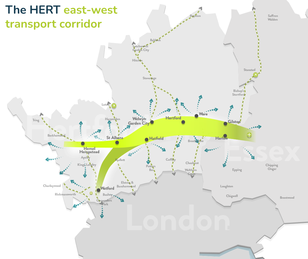
HERT is primarily a proposal to provide a high-frequency bus service Watford to Harlow, also Hemel Hempstead to Harlow, as illustrated below.
Updated information as from March 2024 is to be found at the end of this section.
Could a high-frequency bus service Watford to Harlow put the Abbey line at risk of closure? Could buses compete and thereby cause closure of the line?
Let us consider Hertfordshire County Council's South West Herts Growth and Transport Plan July 2018. This is available here : Referenced papers and reports (opens in new window or tab)
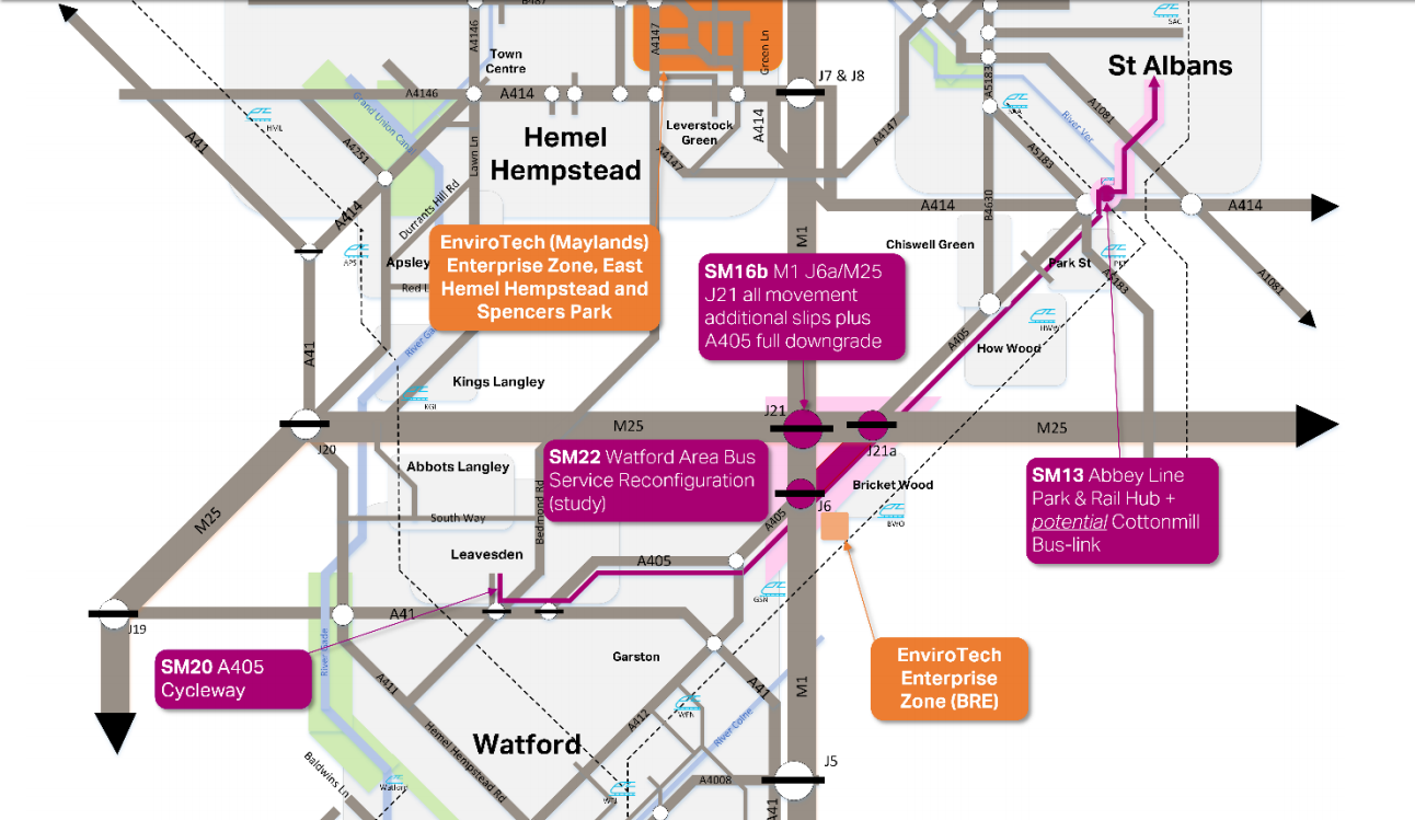
Package 4 on pages 25 and 26, illustrated above, considers the St Albans to Watford corridor. On page 25, ref SM16b includes a planned downgrade of the A405 with reallocation of 1 lane in each direction to buses only. This enables buses to compete with the Abbey line. Most unfortunately, the document creates a misleading impression by claiming at the top of page 25 "The overarching aim of Package 4 is: To maximise the potential of the existing Abbey Line as a rail route by ..."
If buses compete with the Abbey line then it will close. To confirm this, we can ask what plans are in place for the Abbey line. To do this, let us consider the A414 corridor strategy technical report. This is available here : Referenced papers and reports (opens in new window or tab)
The relevant pages are 112 to 118. There are inconsistencies on these pages. Page 118 includes "A new transport interchange associated located adjacent to the A414 and Abbey Line, needs to be well connected with its surroundings. Access will need to be gained by road via the A414, and hence a new junction on the A414 will be required." However this new junction is neither illustrated on page 114 nor on page 117.
Moreover, the South West Herts Growth and Transport Plan July 2018 illustration above includes a "Park and Rail" hub, known to the rest of us as a railway station. This also is neither illustrated on page 114 nor on page 117. In this case, the reason seems to be that there is insufficient space for a new railway station and therefore there never was any intention to build it.
The A414 corridor strategy technical report includes a new junction on the A414 but this has been concealed, included on page 118 but nowhere illustrated. The idea is to build the infrastructure associated with conversion of the Abbey line to a busway for HERT vehicles i.e. connecting on to the A414 whilst claiming that something else is being built, also known as deception.
A note regarding terminology. HERT vehicles are Mass Rapid Transit (MRT) vehicles.
In June 2021 Steer published "Metropolitan Line Extension Alternatives". This is available here : Referenced papers and reports (opens in new window or tab)
On page 116
"9.40 The A414 is a dualled road running from the A41 west of Hemel Hempstead all the way to Chelmsford. This road is characterised by high congestion levels.
9.41 However, the A414 is the key route between Watford – St Albans and Welwyn and has been identified by HCC as a potential route for MRT."
This identifies a design flaw in the MRT proposal. There is no proposal for MRT vehicles to be routed anywhere other than via the A414. As a result, either (choice 1) the A414 is downgraded to permit MRT vehicles to run on a dedicated bus lane, in which case congestion on the A414 is likely to increase, or (choice 2) they share the A414 with other vehicles. In the second case, they are likely to be subject to delay due to congestion, resulting in the entire MRT project being at risk of failure.
As from March 2023, a proposal is being researched : Sharing road space between HERT and driverless cars (opens in new window or tab). The idea seems to be that HERT vehicles run in a segregated lane with driverless cars i.e. not intended to suffer congestion. This still serves to make congestion worse in the other lane.
Some years ago a trial bus service ran between St Albans Abbey and St Albans City stations. It was not a financial success and was withdrawn. However there was no publicity, which suggests the failure could have been anticipated. Moreover there was and is the 724 green line between the two stations.
From intalink.org.uk there is no bus service between Hemel Hempstead and Harlow without one change or more. Nevertheless HERT proposes a high-frequency service between these two towns. The Watford to Harlow service doesn't get stuck in traffic but causes greater congestion than there would otherwise have been in the other lane of the A414. Reduced road capacity serves to undermine Hertfordshire's competitiveness.
HERT uses deception to disguise a plan to close the Abbey line and convert it into a busway. It reduces capacity on the A414 thereby undermining Hertfordshire's competitiveness.
As from March 2024, the plan to close the Abbey line and convert it into a busway is no longer disguised. Hertfordshire County Council Highways and Transport Cabinet Panel agenda pack for meeting on 12 March 2024 includes a HERT update, page 259 onwards. The document is available here : Referenced papers and reports (opens in new window or tab)
Original source : https://democracy.hertfordshire.gov.uk/documents/g5335/Public%20reports%20pack%20Tuesday%2012-Mar-2024%2010.00%20Highways%20and%20Transport%20Cabinet%20Panel.pdf?T=10&#page=261
The plan to convert the Abbey line to a busway is highlighted on page 267 section 9.8 "Engineering feasibility for conversion to a paved, trackless tramway" i.e. busway. The document refers to rubber-tyred "trackless trams" and seems to have been selected in order to try to blur the distinction between buses and rail-based travel.
Earlier section 9.7 in bold type asks county councillors to commit to the HERT project and that the Abbey line would be converted to a busway if it is suitable, subject to further studies. We already know the Abbey line could be converted to a busway since this has been studied and envisaged for some years. No alternative was recognised, ignoring our proposals.
The document suggests that the MRT i.e. bus service formerly from Rickmansworth has been replaced to commence at Croxley.
At the foot of page 261, we find "... mitigate against the adoption of a steel wheel on rail solution". This is deliberate manipulation. HERT attempts to combine Hemel Hempstead to Harlow with West Watford to Harlow as a single proposal. There is no likelihood of a rail-based solution for Hemel Hempstead to Harlow but this does not provide any reason whatsoever for suggesting West Watford to Harlow could not be rail-based and indeed we are proposing exactly this. On page 262 we find "... if the Abbey Line corridor is promoted as the St Albans to Watford section of the HERT". This has always been an objective of HERT, with marketing gloss not making this clear until recently.
On page 266 concerning a more frequent service on the Abbey line we find "Will create severance if level crossings have to be removed". This is deliberately misinformed. There is no reason to replace the vehicle crossing at Watford North with a bridge, the existing crossing being easily able to function with a train service every 30 minutes. Pedestrian crossings at How Wood station and from Cottonmill Lane to Griffiths Way in St Albans could be replaced by bridges if necessary.
On page 269, Essex County Council will be focusing on supporting enhanced connectivity via heavy rail to Stansted Airport.
This is part four. Further information is available in part three : A review of Hertfordshire - Essex Rapid Transit (HERT) (opens in new window or tab).
Hertfordshire - Essex Rapid Transit (HERT) was subject to a public engagement, i.e. consultation, from November 2021 to January 2022. Our response to the public engagement is referenced in part three section "A review of Hertfordshire - Essex Rapid Transit (HERT)".
Shortly after the public engagement, it became apparent that the public engagement was not properly conducted. Reasons for this were compiled at that time and are listed here.
1. The true costs of HERT are hidden. This is documented in our response to the public engagement referenced in part three section "A review of Hertfordshire - Essex Rapid Transit (HERT)". For example, the true costs include the cost of redeveloping Watford Junction.
2. The public engagement claimed that HERT could be implemented as a tramway. This was shown to be false in earlier section "Hertfordshire - Essex Rapid Transit (HERT) will not be trams". Hence HERT creates an illusion for those who are in favour of rail-based travel.
3. HERT is a disguised proposal to convert the Watford Junction to St Albans Abbey line into a busway. This point is summarised earlier in section "HERT converts the Abbey line to a busway".
4. HERT includes an exercise in smoke and mirrors since Hertfordshire County Council claims to be lobbying Whitehall when in fact there is purely cooperation, if not submission. This point is made in part three section "The Abbey line is being undermined".
5. HERT bypasses the processes of democracy, although we suspect this is common also to other Whitehall plans. Firstly, Hertfordshire county councillors (Westminster MPs?) are being briefed to simply play Whitehall's game by being told that the council is lobbying Whitehall, reference the previous point. Secondly, Hertfordshire county councillors believe their policy for the Abbey line is being implemented, when in fact their own officers seem to be under marching orders from Whitehall : this point is made earlier in section "The Croxley Rail Link is not dead".
6. Misleading information was published prior to the public engagement. Two months beforehand, the September 2021 issue of Modern Railways included an article on the Abbey line. With lots of pictures of trains, it gave the impression that the line has a secure future, but made no mention of the plan to convert the line into a busway. For those with a subscription to Modern Railways, the article is https://www.modernrailways.com/article/abbey-flyer-prays-passing-loop
7. HERT undermines an improved east west rail network and therefore undermines the economic growth of the Oxford to Cambridge arc as a whole. This point is made in part three section "A review of Hertfordshire - Essex Rapid Transit (HERT)".
8. HERT is the result of plans made over a number of years on the assumption that east west rail in Hertfordshire is not feasible. Our research calls this assumption in to question. HERT needs to be replaced by a new proposal that brings a St Albans to Hatfield conventional rail corridor in to scope.
We compiled this list with ease, which suggests there are probably further reasons.
A note in passing concerning the Nottingham tram. This was partly funded by a workplace parking levy.
Source : transport policy consultant Stephen Joseph ( https://www.transportfornewhomes.org.uk/our-team/stephen-joseph/ ) speaking in January 2020, time 40:30 - 41:15, youtube video https://www.youtube.com/watch?v=3V4ArxWT_Lw
Another point of interest at time 20:31, Arriva click in Watford is somewhere between a taxi and a bus.
We here discuss connecting the Abbey line to Watford High Street via a rail connection at Watford Junction.
In June 2021 Steer published "Metropolitan Line Extension Alternatives" ( Referenced papers and reports (opens in new window or tab)).
There are three options for Mass Rapid Transit (MRT) in terms of routing through Watford town centre. All three envisage MRT vehicles to Watford Junction via Clarendon Road. They are illustrated on pages 82, 85 and 88, noting the annotation "St Albans Extensions". This confirms conversion of the Abbey line to a MRT/busway requires MRT vehicles to take over the underpass from Station Road to the car parks, rendering the car parks inaccessible and therefore triggering redevelopment of Watford Junction.
The current Network Rail proposals for redevelopment of Watford Junction include adapting or rebuilding the underpass for the use of Mass Rapid Transit (MRT) vehicles. If the underpass can be adapted or rebuilt for MRT vehicles then we suggest it can be rebuilt or realigned for a rail connection, although this does require professional evaluation. This rail connection also triggers redevelopment of the station since the car parks become inaccessible.
If Watford Junction can be redeveloped to enable MRT vehicles to make use of the underpass, then it can be redeveloped for a new rail connection making use of the underpass.
The current plan by Network Rail i.e. for MRT envisages a covered bus station on Woodford Road and which is unpopular. Overall the plan was devised prior to the Covid pandemic and is a commercial proposition to capitalise on the land by the provision of offices. It essentially boxes in the station in 1960's-style thinking and also envisages closure of the rail sidings in the vicinity of platform 11 currently used by a concrete-batching plant also for storing an Abbey line train overnight.
Revised plans for redevelopment of the station to enable a new rail connection would reasonably be more adapted to a post-Covid situation. There is some opportunity to capitalise on the land, possibly with more of an emphasis on residential development rather than offices. It is not clear to what extent this would be self-financing. This is a key matter in assessing the capital costs for the proposal.
Redevelopment of the station to enable a rail connection might feature two station entrances, with buses serving one or other of the entrances. In this case, a covered bus station on Woodford Road would hopefully be avoided. It is possible that the sidings in the vicinity of platform 11 would be replaced by new sidings accessed via the Abbey line although we have made no attempt to identify a suitable location for such sidings.
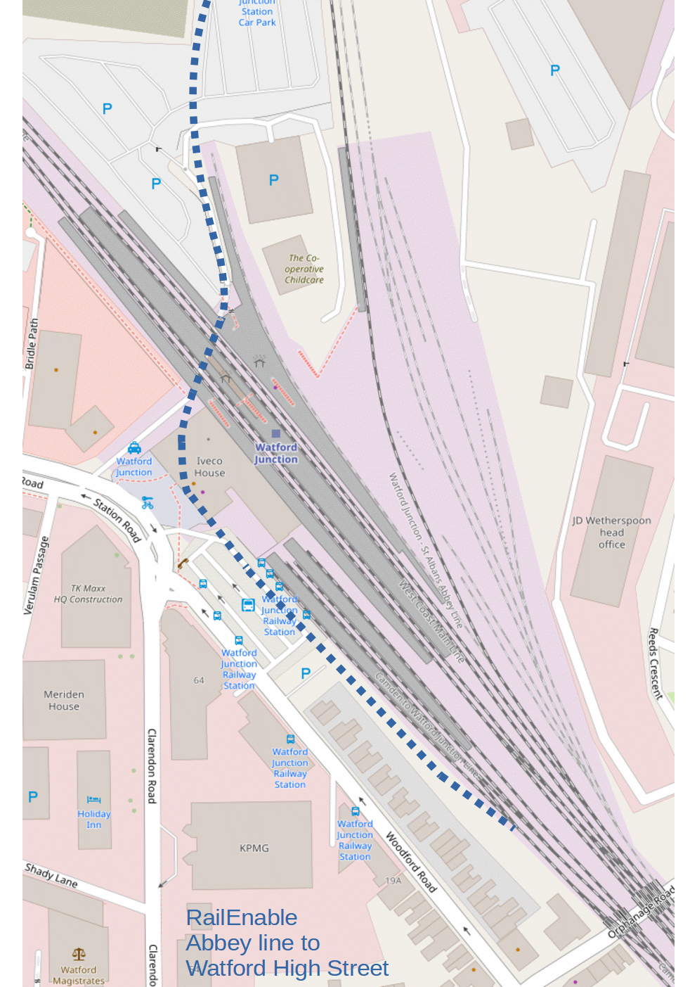
The following illustrates the rail connection at Watford Junction. The Abbey line used to be served by platform 10 i.e. the centrally-located platform. The Abbey line would be reconnected to platform 10, then by means of a rebuilt or realigned underpass to the front of the station and run alongside the existing track to platform 1, connecting onto the London Overground (Lioness) lines. For the purposes of new track, we anticipate no new land purchase would be necessary.
Drawings (diagrammatic maps) are displayed full size for clarity.
Source : openstreetmap.org © OpenStreetMap contributors
An online map of Watford Junction is available here (opens in new window or tab) Source : openstreetmap.org © OpenStreetMap contributors
Since drawing the illustration above, it has become apparent that there are buildings or infrastructure between the tracks and the rear of the houses on Woodford Road. Although thought to be railway land, we have no further information. It may be a signalling centre Infrastructure to the rear of houses on Woodford Road (opens in new window or tab). The best option may therefore be to connect the Abbey line into the low-numbered platforms without a new track running alongside platform 1.
As an alternative to a rebuilt or realigned underpass connecting the Abbey line to the low-numbered platforms, there would seem to be the potential for a flyover, by reference to the above online map, clicking on the link a second time if needed, zooming out and heading south. This would connect the Abbey line to the triangle of land bounded by railway lines and Radlett Road, this being an alternative means of connecting the Abbey line to Watford High Street. As a first estimate, there would be two elevated platforms at Watford Junction in the vicinity of the current Abbey line platform.
As an alternative, Mark E Townend has put forward a proposal for east west light rail at Watford via the Stephenson Way Viaduct. A copy is available at https://railenable.com/pdf/met_watford.pdf . From openstreetmap.org, it seems this could connect onto an existing siding running alongside the WCML main lines to provide a single-track link for light rail.
Tram lines are dangerous including for cyclists. We will never specifically propose a tramway nor support a proposed tramway unless it is segregated, without on-street running. However there are two footpaths beneath the Stephenson Way Viaduct, one on either side of the watercourse. By means of bridges over the watercourse, these could be merged into one footpath beneath the viaduct, leaving an arch free for a dedicated light rail link, not requiring sharing with pedestrians or cyclists.
Courtesy of Google, view of two paths beneath the Stephenson Way Viaduct Two paths beneath the Stephenson Way Viaduct (photo opens in a new window or tab).
The proposal by Mark E Townend for a track passing beneath the Stephenson Way Viaduct is specifically for light rail since the curvature and gradient are thought to be unsuitable for conventional rail.
"Metropolitan Line Extension Alternatives" published by Steer, referenced earlier, refers to this light rail link in section 8.32 although connection on to the Abbey line is not illustrated. It has been specifically associated with "Rail Option 3". Why is it described as complex?
Mark has proposed a tram-train from St Albans Abbey to Rickmansworth. A copy is available at https://railenable.com/pdf/met_metropolitan.pdf . We have a slight reservation about this in that it would require track sharing between light rail, underground and conventional rail systems.
In terms of service, we will first consider conventional rail and then light rail. In terms of conventional rail, the most straightforward choice would seem to be to extend London Overground to St Albans Abbey presumably using Selective Door Operation due to short platforms on the Abbey line. The line is not suitable for upgrade to dual track in its entirety and therefore a service every 10 minutes is not considered to be practicable. We might anticipate a service every 20 minutes. The implication is that some Overground services would terminate at Watford Junction and some continue to St Albans Abbey.
In these revised circumstances the case for the Metropolitan Line Extension (Croxley rail link) would merit reevaluation. This requires a viaduct crossing the A412, River Gade and Grand Union Canal. Envisaged as extending the Metropolitan Line to Watford Junction, a rail connection at Watford Junction offers the possibility of an extension to St Albans Abbey. There is alternatively the future possibility of Oxford to Cambridge via Aylesbury, Watford Junction and St Albans Abbey. An alternative to the Croxley rail link could be an Ebury Way rail link, earlier section "The Croxley Rail Link is not dead".
Subsequent to connecting the Abbey line to Watford High Street, if either the Croxley rail link or Ebury Way rail link were to be implemented, London Overground to St Albans Abbey would probably be replaced by another service on the Abbey line, either the Metropolitan Line or a regional rail service such as Oxford to Cambridge. In either case, the service is routed via Watford High Street. London Overground would revert to the current arrangement terminating at Watford. As a result, we suggest passengers would do well to consider an extension of London Overground to the Abbey station as a means of extending the Abbey line service to Watford High Street i.e. two separate services London Overground to Watford and an extended Abbey line service to Watford High Street combined into one as an interim arrangement. There is no guarantee in the future of a direct service from London Overground stations south of Watford High Street to the Abbey station.
Alternatively, London Overground might be extended via a St Albans to Hatfield line to Welwyn Garden City and Stevenage. The Hertford East service might be extended via Watton at Stone also to Stevenage. These two services might be combined by changing direction at Stevenage to form a single service from Euston to Liverpool Street via Hertfordshire, although we do not know whether this service would form part of Transport for London (TfL), an opportunity for a bunfight. Everyone loves a bunfight, which provides motivation for planning and implementing the service. We envisage trains would change direction at St Albans Abbey, at Stevenage and potentially also at Hertford East. Later section "East west rail at Stevenage" provides further information.
Of all the possibilities we have considered excepting a direct service from the Abbey line on to the WCML e.g. to Euston, the infrastructure required for London Overground to St Albans Abbey forms a useful first stage.
Let us now turn to the possibility of light rail. The provision of a light rail service has considerable implications, for example a maintenance depot and would not be envisaged merely to provide a short service between St Albans Abbey and Watford High Street. A more substantial light rail network could be anticipated e.g. to London Colney.
In the other direction, we might anticipate light rail to Watford High Street and Watford's hospital. Zoom out on the above online map and head south west for details. This would require track sharing between light rail and conventional rail but not Underground trains.
The Abbey line is not suitable for upgrade to dual track in its entirety and therefore a light rail service every 10 minutes is not considered to be practicable. We might anticipate a service every 20 minutes. The light rail vehicles would be high capacity due to the service frequency. As a first approximation they would be akin to articulated conventional trains. They would share track with London Overground between Watford Junction and Watford High Street and would presumably be able to call at conventional platforms.
Following implementation of a light rail link, it would make sense for any redevelopment of Watford Junction to permit connection of the Abbey line to the low-numbered platforms, possibly without laying the track initially. Once the track was in place, conventional rail would operate on the Abbey line, either replacing light rail or sharing track with light rail.
It is unlikely light rail would operate on the MML. Because of the possibility of conventional rail subsequent to light rail, it would be appropriate to plan and safeguard a connection between St Albans Abbey and St Albans City. The track would form a semi-circle, trains changing direction at St Albans Abbey.
The following photos taken by Google streetview turning off Reeds Crescent provide a view from the east of the Abbey line train at Watford Junction platform 11. We suggest it could be appropriate to reserve the land in view for a light rail depot. As an interim arrangement, this land could be used for stabling facilities for conventional rail, hopefully including a train during the day that can be brought on to the Abbey line if the train in operation fails. Behind these photos is further railway land, although not rail-connected, including the Network Rail Watford depot welding store and car parks. A view from the east of Watford Junction and A further view from the east of Watford Junction . Further down the road returning to Reeds Crescent there is another view of the train at platform 11, again with railway land in the foreground. Given that the train was in the station throughout the visit by the Google streetview car it seems likely, sadly, that the train was out of service. Another view of the train at Watford Junction platform 11 (all open in new window or tab).
Options for east west rail at Watford Junction have to take account of Radlett Strategic Rail Freight Interchange (SRFI) i.e. freight terminal on the former Radlett (Handley Page) airfield site. Information by objectors to the freight terminal at https://twitter.com/SaveStAlbansftf and at https://www.savestalbans.com/
Radlett SRFI can be assessed by viewing the illustrative masterplan provided by the developers Illustrative Masterplan who have also made available a site location plan Site Location Plan (both open in a new window or tab). It may be worthwhile to keep the first of these open whilst reading the following.
Radlett freight terminal makes St Albans Abbey station indispensable for east west rail travel, since the lines illustrated in solid red below are obstructed by the freight terminal and cannot be implemented. The line in light blue illustrates the rail chord giving rail access to the freight terminal. The shaded area is an illustration of the freight terminal site masterplan i.e. the ground that it occupies.
We have purchased a vintage map of Watford showing current and former railway lines. Here is an electronic copy, which complements the above diagrammatic map. Vintage map of Watford (opens in new window or tab).
There are lots of options for east west rail at Watford Junction and vicinity. Here is a list of some of these options. Some of these are alternatives, whereas some of these can be combined. This list could be written in any order and therefore we do not refer to the option numbers later.
Options 1 to 4 were discussed in earlier section "Connecting the Abbey line to Watford High Street".
Option 1. Connecting the St Albans Abbey line to Watford High Street by means of a redeveloped underpass at Watford Junction.
Option 2. Connecting the St Albans Abbey line to Watford High Street by means of a flyover at Watford Junction.
Option 3. A light rail connection between the St Albans Abbey line and Watford High Street, at Watford Junction, passing beneath the Stephenson Way Viaduct.
Option 4 : A tunnelled connection from Watford (Met) to the St Albans Abbey line via Watford Junction with a new station stop Watford Parade, illustrated with red dots above.
Options 5 and 6 were discussed in earlier section "The Croxley Rail Link is not dead".
Option 5 : The Croxley rail link, illustrated in orange.
Option 6 : An Ebury Way rail link, illustrated in purple.
Option 7 : St Albans Abbey to St Albans City in a semi-circle, trains changing direction at St Albans Abbey, illustrated in dark blue.
Option 8 : St Albans Abbey to Radlett, illustrated in dark blue.
Option 9 : St Albans Abbey to London Colney, illustrated in orange. Further information on this is available on the hertsrail.org.uk home page also in part three section "A new line from St Albans Abbey". In terms of coexistence with Radlett SRFI, in an ideal world, the line would connect onto the underpass beneath the Midland Main Line (MML) built to provide rail access to the SRFI. If this is not achievable, a separate Midland Main Line (MML) bridge or underpass would need to be built and probably aligned a little differently.
Option 10 : Radlett to London Colney, illustrated in purple. This might branch off the line in light blue itself requiring an upgrade from a freight link to be used by passenger services.
Option 11 : St Albans City to London Colney, illustrated in dark green.
Option 12 : A new line northwards from St Albans Abbey, not illustrated, e.g. serving new developments at Hemel Hempstead.
This online map Stevenage (all links open in a new window or tab) shows Stevenage, Knebworth and Watton at Stone. It illustrates the opportunity for trains to change direction at Stevenage providing a service via Knebworth and Watton at Stone. This is east west rail at Stevenage. By zooming in on Stevenage station, the currently-provided infrastructure is available to view. This is also illustrated below, fast lines not shown. How would east west rail at Stevenage be useful? South east of Watton at Stone, let us envisage a rail link between Ware and Watton at Stone. Moving southwards on the ECML, let us envisage a new line from Hatfield via London Colney connecting northwards onto the MML to St Albans City, southwards onto the MML to Radlett and also to St Albans Abbey on the line to Watford. This provides east west rail in Hertfordshire.

In this section we discuss infrastructure upgrade to provide east west rail at Stevenage, that is, a service via Knebworth and Watton at Stone. There are several options and these are illustrated below.

The first option is shown in red. This requires a new track on the eastern side of the ECML to a new platform, platform 0. A train from Watton at Stone changes direction at this new platform then continues on the ECML southbound slow line to Knebworth. In the opposite direction, a train from Knebworth changes direction at a high-numbered platform and uses the existing bridge under the ECML to proceed to Watton at Stone. In the direction Knebworth to Watton at Stone, this also applies for all other options. Option 1 requires the purchase of land and also requires earthworks.
The second option is shown in orange. This requires the southern part of option 1 together with a new bridge over or under the ECML to the high-numbered platforms. This would be located between the A602 Broadhall Way and A1070 Six Hills Way. This and all other options assume no changes to these road bridges. We might anticipate the existing bridge beneath the ECML used in a northbound (north-west) direction and the new bridge used in a southbound (south-east) direction.
The third option is shown in green. There are several elements to the infrastructure. Firstly a new chord from the northbound ECML slow line to what is currently the westernmost track. Secondly a new bridge beneath the ECML in the vicinity of the existing bridge although oriented differently. Both bridges would be bi-directional. Thirdly a connecting chord for a southbound train having passed beneath the ECML by means of the existing bridge across what is currently arable land onto the ECML southbound line. Fourthly an additional westernmost track located between the two road bridges: this track would also be partially required for option 2. Let us describe the basic operation of this option. It is anticipated that there would be two platforms serving northbound ECML slow services, preferably as a platform pair and this would require significant changes to the existing platform arrangements. At its most basic the operation is as follows: a northbound ECML slow train could call at the western of these two platforms, the track on the east being available for a train either from or to Watton at Stone. A northbound ECML slow train could call at the eastern of these two platforms, the track on the west being available for a train to Knebworth. Because of this switching capability dependent on other train movements, it is suggested the two platforms would form a platform pair enabling a switch of platforms at short notice: the train is behind you.
The fourth option is shown in blue. If implemented in both directions, trains between Watton at Stone and Knebworth do not call at Stevenage. This is a bypass and, with a link from Watton at Stone to Ware, might be considered as a cut-down equivalent to the dismantled former line eastwards from Welwyn Garden City to Hertford North and Hertford East. It is possible option 4 might be implemented westbound only not requiring a new bridge over or under the ECML, in which case trains westwards do not call at Stevenage but trains eastwards call at a high-numbered platform at Stevenage: the word bodge comes to mind.
None of these options require any changes to the A602 Broadhall Way nor A1070 Six Hills Way road bridges. We do not know whether both of these bridges would be able to accommodate an additional track on the western side of existing tracks. If so, we have a fifth option, not illustrated. This bears a resemblance to option 3 but with some changes. There would be only one platform for northbound ECML slow trains. The new chord from the northbound ECML slow line to what is currently the westernmost track would not be required. With the provision of an additional track the switching capability of option 3 is not required. There is an embankment and retaining wall to the north of Broadhall Way which would need to be addressed. If this option is feasible, it could prove to be the best option.
Online tools can be used to assess these options, in addition to openstreetmap.org referenced earlier and are now discussed.
A live track diagram shows the location of trains at Stevenage: either
OpenTrainTimes : trains at Stevenage or
Traksy : trains at Knebworth (either opens in a new window or tab).
Of note is the local Hertford loop service from Moorgate via Watton at Stone terminating at Stevenage platform 5, then returning to Moorgate.
The live track diagram also shows the asphalt plant connected to the ECML up slow line although we do not know when a train arrives or departs.
Whilst on the subject, given the photos of asphalt plant personnel at
https://www.tarmac.com/locations/Stevenage-Asphalt-Plant/
which member of staff drives the train?
Dragging the yellow pegman lower right on Google maps gives access to streetview. Of note are views northwards and southwards from the two road bridges Broadhall Way and Six Hills Way.
We have been unable to locate a youtube cab ride or driver's eye view video for Stevenage platform 1 or platform 5. Here are youtube videos we have found.
youtube.com/watch?v=vbVs2m0HdhU southbound on ECML fast line. As from 1:49:45, having called at Stevenage. Junction on left for Hertford loop at 1:51:30.
youtube.com/watch?v=5DCGyoWR7m0 as from 20:02 northbound on ECML fast line
youtube.com/watch?v=8gZD7tiM--M from the Hertford loop onto the ECML in 2017. Stevenage platform 5 and access track to it not yet built. Road bridge at 35:05 prior to passing beneath the ECML
youtube.com/watch?v=dFzZh3jZIYQ southbound from Stevenage platform 4 in the late 1980's turning off for the Hertford loop at 1:30, passing beneath the ECML at 2:10
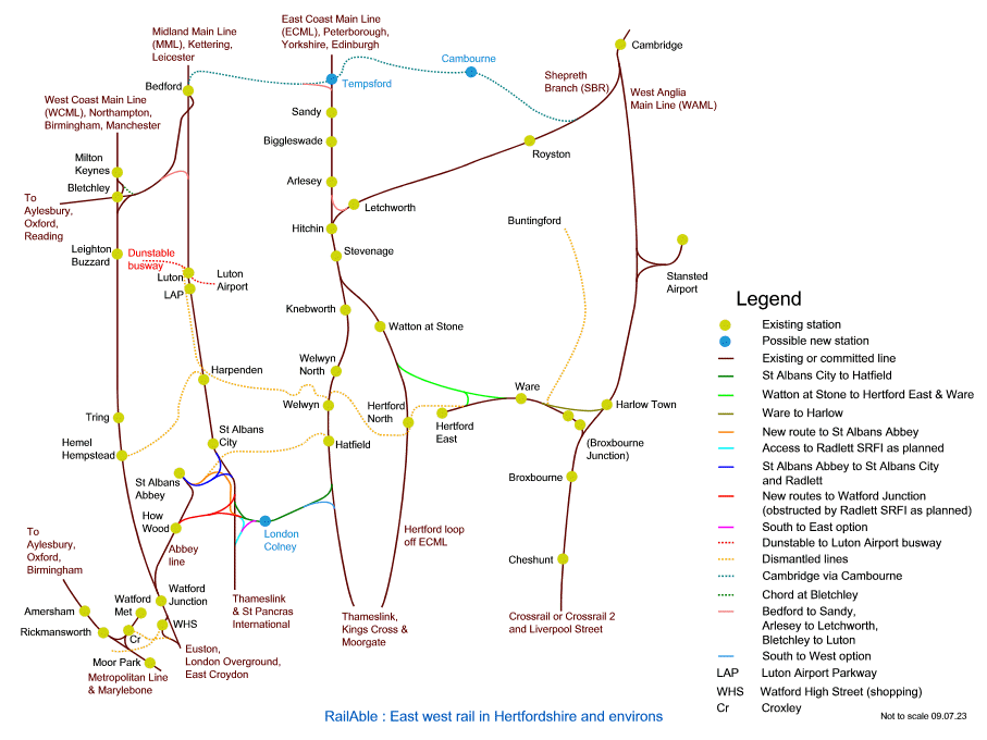
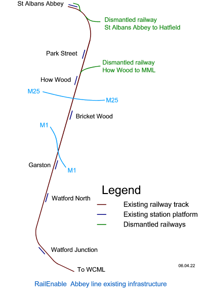
The Abbey line is a single-track line, permitting a train either in the direction Watford Junction to St Albans Abbey or in the opposite direction but not both at the same time. For reference, we provide a diagrammatic map of the existing Abbey line infrastructure.
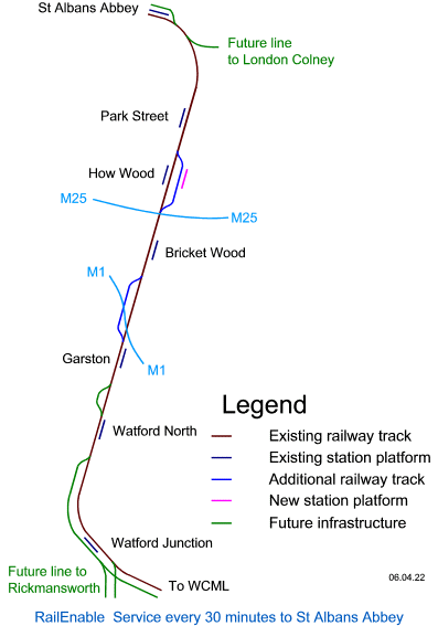
In this section we discuss possible future infrastructure for the Abbey line. There are no specific proposals in this section. There is potential to upgrade the line but not to dual track in its entirety.
There is the possibility of east west rail at Watford Junction. There is the possibility of direct services on to the WCML. There is the possibility of extension of the line to London Colney and/or Radlett and/or St Albans City. There is the possibility of a northwards extension.
An example service on the line could be Watford - St Albans every 30 minutes or every 20 minutes, or Watford - St Albans - London Colney every 30 minutes or every 20 minutes. Taking account of the leaf fall period and of recovery from late running, these various possibilities would require infrastructure upgrade.
Potential infrastructure upgrades illustrated below include :
(i) two platforms at Watford Junction with dual track at least part way to Watford North;
(ii) a passing loop between Watford North and Garston;
(iii) a dual track section or at least a passing loop between Garston and Bricket Wood;
(iv) facility for trains to pass at Bricket Wood - discussed for many years although not illustrated below;
(v) facility for trains to pass at How Wood or in the vicinity;
(vi) two (or more) platforms at St Albans Abbey, bringing a disused platform back into use and possibly lengthening it;
(vii) re-opening the head of the former line from St Albans to Hatfield potentially as single track passing over the river Ver,
becoming dual track on heading southwards towards London Colney.
Regarding a dual track section or at least a passing loop between Garston and Bricket Wood, the M1 bridge permits dual track. However on approach to Garston from here construction of the line featured earthworks and which we think would not permit dual track. So dual track in the immediate vicinity of the M1 bridge would seem to be feasible but not further southwards towards Garston. In the other direction, we do not know what the obstructions for dual track to Bricket Wood station would be. The Mount Pleasant Lane bridge does not permit dual track.
We have proposed a train passing facility at How Wood or in the vicinity, rather ironically possibly the only item on this list that requires land purchase. The proposal is in part three : Trains passing at How Wood and ticket checks at the Abbey station . The two trains pass at How Wood or vicinity with more time available to change ends at the Abbey station than at Watford Junction. In the event of late running there may not be sufficient time for a journey to Watford Junction and back, potentially leading to a shortened service from St Albans Abbey to Bricket Wood, Garston or Watford North and then return. At some future point, planning may be undertaken for the various possible services listed earlier e.g. a service every 20 minutes Watford - St Albans or Watford - St Albans - London Colney with associated infrastructure upgrades specifically designed. At this point, an interim arrangement could be to implement a subset of the infrastructure to permit recovery from late running of a Watford - St Albans service every 30 minutes without service shortening. The means to achieve this would be a second passing loop on the line. During normal operation, trains pass at How Wood or vicinity. During recovery from late running, trains pass using the second passing loop. We have illustrated this by selecting a dual track section or at least a passing loop between Garston and Bricket Wood i.e. coloured blue with all other future infrastructure coloured green.
On a separate point, could Digital Automatic Coupling (DAC) be leveraged to combine two services into one for entry to the line and to divide trains to form two services on departure?
Oxford to Cambridge via Watford Junction would require a connecting chord Bicester to Aylesbury.
As a first approximation, this might follow the route of the former Metropolitan Railway (openrailwaymap.org) from Verney Junction, turning southwards past East Claydon Substation and Hogshaw connecting into Golding Spring Central. Ideally a south-to-east chord from this would serve Aylesbury to Winslow and Bletchley, replacing what seems to be the planned route alongside High Speed 2 and thereby a shorter route for Aylesbury to Bletchley.
For Bicester to Aylesbury, this avoids Calvert Jubilee Nature Reserve at Calvert Junction.
Here we will discuss options for an Oxford to Cambridge service via St Albans.
It should be borne in mind that our diagrammatic maps are intended to illustrate railway infrastructure and are not to scale.
We will commence with options that are rather obscure. The first option involves less infrastructure enhancements than subsequent options. A train from Oxford changes direction at Bletchley, continuing to Watford and Watford South Junction, which is signalled for trains to change direction. Entering the Abbey line, the train continues via St Albans City, Luton Airport Parkway, Luton and Bedford to Cambridge. This would not make use of the Bletchley to Bedford line. There would be two Abbey line platforms at Watford Junction and services would presumably not call at the main line platforms. It has to be admitted that this route is circuitous.
The primary infrastructure enhancement to enable this is Watford Junction to St Albans City by changing direction at St Albans Abbey, coloured blue. Trains would change direction at three locations Bletchley, Watford South Junction and St Albans Abbey and this would not be regarded as anything other than an interim proposal.
A variation of this would be via a St Albans to Hatfield line. The route would be to change direction at Bletchley, at Watford South Junction also at St Albans Abbey then via London Colney and Hatfield.
Alternative options might be listed in any order. With a Bletchley to Luton connecting chord, illustrated above and known as the Stewartby chord, we might anticipate a service between Oxford and Cambridge via Bletchley, Luton and Luton Airport Parkway, St Albans City, London Colney, Hatfield, Welwyn Garden City, Stevenage, Hitchin and Letchworth. This would require a St Albans to Hatfield line. This service does not change direction.
A variation of this service would be to change direction at Bedford.
The remaining options listed here require east west rail at Watford Junction, specifically connecting Rickmansworth to St Albans Abbey. They also require a chord from Bicester to Aylesbury (previous section and not illustrated).
For a service via St Albans City, an Oxford to Cambridge service could operate via Aylesbury, Rickmansworth, Watford Junction, St Albans Abbey (change of direction), St Albans City, Luton Airport Parkway, Luton and Bedford. This would not make use of the Bletchley to Bedford line nor require a St Albans to Hatfield line.
A service between Oxford and Cambridge, not via St Albans City, could operate via Aylesbury, Rickmansworth, Watford Junction, St Albans Abbey (change of direction), London Colney, Hatfield, Stevenage and Letchworth not requiring paths (space/time slots) on the Midland Main Line. This would not make use of the Bletchley to Bedford line. It would require a St Albans to Hatfield line.
Changing direction at Stevenage was discussed in earlier section "East west rail at Stevenage". Options for changing direction at Stevenage to be routed via Ware have not been included and are now outlined. There are probably three routes for this : via Aylesbury or changing direction at Bletchley or via Luton and Luton Airport Parkway. Of these, the first is the most strategically interesting since it provides an alternative to Hertfordshire - Essex Rapid Transit (HERT) by connecting Rickmansworth to Harlow. The route is Oxford, Aylesbury, Rickmansworth, Watford Junction, St Albans Abbey (change of direction), London Colney, Hatfield, Welwyn Garden City, Stevenage (change of direction), Watton at Stone, Ware, Harlow Town, Cambridge. This is much slower than Oxford to Cambridge via Bedford and Tempsford but serves centres of population.
The significance of any of these services is that it provides good town-to-town and town-to-city connectivity in the region, bearing in mind the market is understood to be limited for direct travel between the cities of Oxford and Cambridge.
This section has been copied from part three section "Potential rail services" and updated. If there remains anything to update do let us know.
East west rail in Hertfordshire offers the potential for a wide range of rail services. Let us attempt to list at least some of them. Readers may be able to find others.
Note 1. These services change direction at Stevenage. Of the services listed, we would not expect more than one service in each direction every 30 minutes to change direction at Stevenage i.e. for travel via Knebworth and Watton at Stone. This note applies to services 1, 2, 9, 10, 22, 23, 25, 1a, 2a, 16a, 16b, 16c, 16d, 21a, 21b, 21c, 21d, 26a, 26c, 27a, 27c, 28a, 28c, 29a, 29c.
Note 2. These services are routed via Watford Junction and St Albans City requiring infrastructure for Rickmansworth to Watford Junction and for east west rail at Watford. These services change direction at St Albans Abbey, limiting service frequency. This note applies to services 4, 5, 12, 4a.
Note 3. These services require a facility at Watford Junction to change direction between Hemel Hempstead on the WCML and the Abbey line. This can be achieved at Watford South junction which provides the required signalling. This note applies to services 26a, 27a, 28a. These services are obscure.
Note 4. These services can no longer be implemented. They required infrastructure for Rickmansworth to Watford Junction, for east west rail at Watford and for Watford to London Colney, however the latter is no longer possible since obstructed by Radlett SRFI. This note applies to services 1, 6, 9, 1a.
Note 5. Elizabeth line circular services are discussed in our article Elizabeth line circular service via Reading This note applies to services 9, 10, 11, 12.
1. Oxford to Stansted Airport via Aylesbury, Watford Junction, London Colney, Stevenage and Harlow. This service changes direction at Stevenage - note 1. Note 4.
2. Oxford to Stansted Airport via Bletchley, Luton, London Colney, Stevenage and Harlow. This service changes direction at Stevenage - note 1.
3. Oxford to Stansted Airport via Bletchley, Bedford, Sandy, Stevenage and Harlow.
4. Oxford to Stansted Airport via Aylesbury, Watford Junction, St Albans City, Bedford, Sandy, Stevenage and Harlow. Note 2.
5. Oxford to Cambridge via Aylesbury, Watford Junction, St Albans City, Bedford and Tempsford. Note 2.
6. Oxford to Cambridge via Aylesbury, Watford Junction, London Colney, Stevenage and Letchworth. Note 4.
7. Oxford to Cambridge via Bletchley, Luton, St Albans, London Colney, Stevenage and Letchworth.
8. Oxford to Cambridge via Bletchley, Bedford and Tempsford.
9. Elizabeth line circular service via Reading, Watford Junction, London Colney, Stevenage and Broxbourne. This service changes direction at Stevenage - note 1. Note 4, note 5.
10. Elizabeth line circular service via Reading, Bletchley, Luton, London Colney, Stevenage and Broxbourne. This service changes direction at Stevenage - note 1. Note 5.
11. Elizabeth line circular service via Reading, Bletchley, Bedford, Sandy, Stevenage and Broxbourne. Note 5.
12. Elizabeth line circular service via Reading, Watford Junction, St Albans City, Bedford, Sandy, Stevenage and Broxbourne. Note 2, note 5.
13. Hertford loop service, currently terminating at Stevenage platform 5, extended via Sandy, Bedford and Bletchley to Oxford. Opportunity for travel between Oxford and Cambridge by changing at Hitchin. Provides an ECML regional interchange for Oxford at Stevenage. This frees up Stevenage platform 5 for use by a service changing direction at Stevenage.
14. Oxford to Peterborough via Bletchley and Bedford. Necessitates a west-to-north connection on to the ECML, not illustrated. Travel between Oxford and Cambridge by changing at Peterborough. Provides an ECML regional interchange for Oxford at Peterborough.
15. Thameslink via Radlett to London Colney.
16. Thameslink via Radlett, London Colney and Hatfield. Destination not specified. Includes services 16a, 16b, 16c, 16d below : intended in conjunction with a local service from Watford.
17. Thameslink via a South to West chord, London Colney and St Albans City to Bedford. Extensions of this service via Sandy, Stevenage and Broxbourne or Harlow with some similarity to services 16a, 16b, 16c, 16d could be added : these extensions potentially intended in conjunction with a local service from Watford but considered unlikely.
18. Thameslink via St Albans City to Bedford extended via Tempsford to Cambridge.
19. Thameslink via St Albans City to Bedford extended via Sandy and Stevenage to be a circular service.
20. Thameslink to Oxford via Luton and Bletchley.
21. Thameslink via the ECML to Stevenage, where the service changes direction - note 1. Consists of services 21a, 21b, 21c, 21d below.
22. Service between Bedford and Harlow, via Luton, St Albans City, London Colney, Hatfield, Welwyn Garden City, Stevenage and Hertford East. This service changes direction at Stevenage - note 1. Alternatives are service 2 or 2a.
23. Service between Watford Junction and Welwyn Garden City. Watford Junction and intermediate stations to St Albans Abbey, London Colney, Hatfield, Welwyn Garden City. This service changes direction at St Albans Abbey. With Watton at Stone to Hertford East, continues via Stevenage and Watton at Stone to Hertford East, changing direction at Stevenage - note 1. With Ware to Harlow, continues to Harlow, changing direction at Hertford East. This service could be extended to be Euston to Stansted Airport.
24. Service via Aylesbury, Bletchley and Luton. Possibly a Thameslink service to Watford Junction via Luton, Bletchley, Aylesbury and Rickmansworth.
25. Extension of the current Hertford East service to Stevenage by changing direction at Hertford East. This service could then change direction at Stevenage, note 1, and continue via Welwyn Garden City, London Colney and St Albans Abbey to Watford Junction. This service could continue beyond Watford Junction to Euston, providing an "out and back" service between Liverpool Street and Euston via Hertfordshire towns. This possesses similarities to service 23.
26. Service between Hemel Hempstead, Stevenage and Hertford North. This service takes into account that Hertfordshire County Council is headquartered in Hertford with satellite sites in Stevenage and Hemel Hempstead. This would probably be an extension of the existing Hertford loop service i.e. the service via Hertford North currently terminating at Stevenage. Consists of services 26a, 26b, 26c below. Routes via Cambridge not included. These can be combined, e.g. 26a and 26c combined provide a circular service however, in this case, the frequency of changes of direction at Stevenage would need to be considered. Distinct from service 29 in that service does not commence at Euston.
27. Service between Hemel Hempstead, Stevenage and Broxbourne. Consists of services 27a, 27b, 27c below. Routes via Cambridge not included. These are variations of services 26a, 26b, 26c.
28. Service between Hemel Hempstead, Stevenage and Harlow. Consists of services 28a, 28b, 28c below. Routes via Cambridge not included. These are variations of services 26a, 26b, 26c.
29. Service between Watford Junction, Stevenage and Hertford North. This service takes into account that Hertfordshire County Council is headquartered in Hertford with satellite sites in Stevenage and Hemel Hempstead. This would probably be an extension of the existing Hertford loop service i.e. the service via Hertford North currently terminating at Stevenage. Distinct from service 26, the service would commence at Euston, providing an "out and back" service. Consists of services 29a, 29b, 29c. These services are not combined. They are included in the summary at the end of this article.
30. Watford Junction circular service. Watford Junction and intermediate stations to St Albans Abbey, London Colney, Hatfield, Welwyn, Stevenage, Sandy, Tempsford, Bedford, Bletchley, Hemel Hempstead, Watford Junction. This requires a facility at Watford Junction to change direction between the WCML and the Abbey line : note 3. This provides a service between Hemel Hempstead and Welwyn.
31. Thameslink to St Albans Abbey or via St Albans Abbey.
The following four services are Oxford to Stansted Airport services via Harlow modified to run to Cambridge instead of to Stansted Airport. They are modified versions of services 1 to 4.
1a. Oxford to Cambridge via Aylesbury, Watford Junction, London Colney, Stevenage and Harlow. This service changes direction at Stevenage - note 1. Note 4.2a. Oxford to Cambridge via Bletchley, Luton, London Colney, Stevenage and Harlow. This service changes direction at Stevenage - note 1.
3a. Oxford to Cambridge via Bletchley, Bedford, Sandy, Stevenage and Harlow.
4a. Oxford to Cambridge via Aylesbury, Watford Junction, St Albans City, Bedford, Sandy, Stevenage and Harlow. Note 2.
Services 16a, 16b, 16c, 16d are Thameslink services via Radlett. These services change direction at Stevenage - note 1.
16a. Thameslink via Radlett, London Colney, Stevenage and Broxbourne returning to London, perhaps Stratford or Liverpool Street.16b. Thameslink via Radlett, London Colney and Stevenage, changing direction at Broxbourne (or vicinity) for Harlow and Stansted Airport or Cambridge.
16c. Thameslink via Radlett, London Colney, Stevenage and Harlow to Stansted Airport or Cambridge.
16d. Thameslink via Radlett, London Colney, Stevenage to Hertford North. This would probably be an extension of the existing Hertford loop service i.e. the service via Hertford North currently terminating at Stevenage. This service is included in the summary at the end of this article.
Service 21 consists of services 21a, 21b, 21c, 21d. These services change direction at Stevenage - note 1.
21a. Thameslink via the ECML, Stevenage and Broxbourne returning to London, perhaps Stratford or Liverpool Street.21b. Thameslink via the ECML and Stevenage, changing direction at Broxbourne (or vicinity) for Harlow and Stansted Airport or Cambridge.
21c. Thameslink via the ECML, Stevenage and Harlow to Stansted Airport or Cambridge.
21d. Thameslink via the ECML, Stevenage to Hertford North. This would probably be an extension of the existing Hertford loop service i.e. the service via Hertford North currently terminating at Stevenage.
Service 26 consists of services 26a, 26b, 26c. Service 26a can be combined with 26b or 26c to provide a service via Hemel Hempstead. If 26a and 26c are combined, the frequency of changes of direction at Stevenage would need to be considered.
26a. Hemel Hempstead, Watford Junction and intermediate stations to St Albans Abbey, London Colney, Hatfield, Welwyn, Stevenage, Hertford North. This requires a facility at Watford Junction to change direction between the WCML and the Abbey line : note 3. This service also changes direction at Stevenage - note 1.26b. Hemel Hempstead, Bletchley, Bedford, Tempsford, Sandy, Stevenage, Hertford North.
26c. Hemel Hempstead, Bletchley, Luton, St Albans City, London Colney, Hatfield, Welwyn, Stevenage, Hertford North. This service changes direction at Stevenage - note 1.
Service 27 consists of services 27a, 27b, 27c. Service 27a can be combined with 27b or 27c to provide a service via Hemel Hempstead. If 27a and 27c are combined, the frequency of changes of direction at Stevenage would need to be considered.
27a. Hemel Hempstead, Watford Junction and intermediate stations to St Albans Abbey, London Colney, Hatfield, Welwyn, Stevenage, Hertford East, Ware, Broxbourne. This requires a facility at Watford Junction to change direction between the WCML and the Abbey line : note 3. This service also changes direction at St Albans Abbey, at Stevenage - note 1 and at Hertford East.27b. Hemel Hempstead, Bletchley, Bedford, Tempsford, Sandy, Stevenage, Hertford East, Ware, Broxbourne. This service changes direction at Hertford East.
27c. Hemel Hempstead, Bletchley, Luton, St Albans City, London Colney, Hatfield, Welwyn, Stevenage, Hertford East, Ware, Broxbourne. This service changes direction at Stevenage - note 1 and at Hertford East.
Service 28 consists of services 28a, 28b, 28c. Service 28a can be combined with 28b or 28c to provide a service via Hemel Hempstead. If 28a and 28c are combined, the frequency of changes of direction at Stevenage would need to be considered.
28a. Hemel Hempstead, Watford Junction and intermediate stations to St Albans Abbey, London Colney, Hatfield, Welwyn, Stevenage, Hertford East, Ware, Harlow. This requires a facility at Watford Junction to change direction between the WCML and the Abbey line : note 3. This service also changes direction at St Albans Abbey, Stevenage - note 1 and at Hertford East.28b. Hemel Hempstead, Bletchley, Bedford, Tempsford, Sandy, Stevenage, Hertford East, Ware, Harlow. This service changes direction at Hertford East.
28c. Hemel Hempstead, Bletchley, Luton, St Albans City, London Colney, Hatfield, Welwyn, Stevenage, Hertford East, Ware, Harlow. This service changes direction at Stevenage - note 1 and at Hertford East.
Service 29 consists of services 29a, 29b, 29c. These services are from Euston and are not combined.
29a. Euston, Watford Junction and intermediate stations to St Albans Abbey, London Colney, Hatfield, Welwyn, Stevenage, Hertford North. This provides a direct service between Euston and stations on the Abbey line i.e. without having to change at Watford Junction. This service changes direction at St Albans Abbey, also at Stevenage - note 1.29b. Euston, Watford Junction, Hemel Hempstead, Bletchley, Bedford, Tempsford, Sandy, Stevenage, Hertford North.
29c. Euston, Watford Junction, Hemel Hempstead, Bletchley, Luton, St Albans City, London Colney, Hatfield, Welwyn, Stevenage, Hertford North. This service changes direction at Stevenage - note 1.
Regional ECML services via Stevenage and Broxbourne to Liverpool Street or Stratford are within scope of our project : "ECML two track section between Knebworth and Welwyn". Such services are not considered here.
The following have not been included :
Oxford services via Hertfordshire towns returning to Oxford.
Cambridge services via Hertfordshire towns returning to Cambridge.
Cambridge to Stansted Airport via Hertfordshire towns.
Western circular service Bletchley, Aylesbury, Watford Junction, St Albans City, Luton, Bletchley. Note 2.
Eastern circular service Bedford, Luton, London Colney, Stevenage, Sandy, Bedford.
Figure of 8 service by combining the above two services.
Outer circular service Bletchley, Aylesbury, Watford Junction, London Colney, Stevenage, Sandy, Bedford, Bletchley.
No doubt there are others.
The line between Tempsford and Cambridge is used by services 5, 8, 18.
The line eastwards from Bedford joining the ECML at Tempsford for Stevenage is used by services 3, 4, 11, 12, 13, extensions to 17, 19, 3a, 4a, 26b, 27b, 28b, 29b.
The chord between Bletchley and Luton is used by services 2, 7, 10, 20, 24, 2a, 26c, 27c, 28c, 29c.
The Marston Vale line i.e. the line between Bletchley and Bedford is used by services 3, 8, 11, 3a, 26b, 27b, 28b, 29b.
Direct travel between Luton Airport Parkway and Stansted Airport is provided by services 2, 4.
Direct travel between Aylesbury and Luton is provided by services 4, 5, 12, 4a, 24. Note 2 applies to all of these except service 24.
Digital Automatic Coupling (DAC) is currently in use for freight trains. It is also thought to be in limited use for passenger trains, although not in the UK, to our knowledge.
Taking inspiration from section "The economic value of east west rail in Hertfordshire" and envisaging the use of Digital Automatic Coupling (DAC) to attach trains in order to combine two services into one or to divide trains to form two services out of one, an exercise could be to plan connectivity across the Oxford to Cambridge arc with a wide range of direct services.
An example of Digital Automatic Coupling (DAC) might be a train from A arrives at C and is divided into two with space between them. A train from B arrives on a second track and is positioned in the middle. The front portions are attached and proceed to D, the rear portions attached and proceed to E. We are then provided with services A to D, A to E, B to D and B to E.
It is likely only one service would change direction at Stevenage. We might consider splitting the above example of DAC as follows. A train from Oxford via Bletchley and Luton arrives at London Colney where it divides into two with space between them. A train from Oxford via Aylesbury and Watford Junction arrives on a second track and is positioned in the middle. The combined train proceeds onto the ECML, changes diection at Stevenage, proceeds via Watton at Stone and Ware to Harlow Town. Here the train divides, one train continuing to Cambridge, the other to Stansted Airport.
Mark E Townend has put forward a proposal for light rail to terminus platforms at St Albans City (2 pages). A copy is available at https://railenable.com/pdf/met_stalbans.pdf . Taking some inspiration from this, we might propose a light rail link in a semicircle from St Albans Abbey to St Albans City. The feasibility of light rail beside the Midland Main Line would need investigation. Online tools for this include openstreetmap.org and Google maps.
It seems clear that there is insufficient space between an office block and the railway line. The office block would be partly or completely removed.
Here are some youtube videos.
northbound: youtube.com/watch?v=77ZXgaCmmqY as from 15:50, with an introduction to the Abbey line as from 15:00
northbound: youtube.com/watch?v=6eC_x_kUCC0&t=206s as from 20:05
southbound: youtube.com/watch?v=NUf7OF90FdY as from 1:19:40
The service on the Abbey line used to operate every 45 minutes, albeit hourly on Sundays and with a journey time of 16 minutes : Abbey line timetable 15 May - 10 December 2022 (opens in new window or tab).
Service frequency on the line was reduced as from 11 December 2022. This was announced at a "Stakeholder conference" https://www.dec22timetablechange.co.uk/ and documented in West Coast Mainline December 2022 Timetable changes by route (opens in new window or tab). By searching this document for Abbey, the following is found "45 minute service Abbey Line during peak, hourly off peak".
The train operating company London Northwestern Railway (LNwR) provided details in a presentation Abbey line timetable options (may result in document being downloaded).
When the service operated every 45 minutes, there were 5 minutes to change ends at St Albans Abbey and 8 minutes at Watford Junction. However, on slide 3 of their presentation, London Northwestern Railway (LNwR) states that the timetable was too tight and therefore they wished to reduce service frequency. This used to be one of the most reliable train services in Britain. The line has not changed over the intervening years although the campaign to secure the future of the line has lost momentum in recent years. The implication is that, with an active campaign for the future of the line, the service will be reliable, this in itself casting doubts on the LNwR claim that the timetable was too tight. Therefore the justification for reducing service frequency was questionable.
To assess the LNwR claim that the timetable was too tight, we can compare the Abbey line with the Thames Valley branch lines. Firstly, the service between Windsor & Eton Central and Slough. This is provided by a single train with a journey time of 6 minutes, 5 minute turnaround at Slough and 3 minutes at Windsor, resulting in a cycle every 20 minutes. This is tighter than the Abbey line with a 45-minute frequency. There is no intermediate station, but this is not a factor since the dwell times on the Abbey line at the intermediate stations is ample. Later, point 5, we will theorise that the Abbey line timetable could be considered to be tighter at peak times than off-peak, although this is only theoretical : we understand the dwell times at intermediate stations would happily accommodate a significant increase in passenger numbers until the point was reached where not all passengers were able to board the train due to crowding, unlikely on the Abbey line.
Secondly, the service between Henley-on-Thames and Twyford. This is provided by a single train with a journey time of 12 minutes and 3 minute turnaround at either terminus, resulting in a cycle every 30 minutes. This is tighter than the Abbey line with a 45-minute frequency. It seems the timetabled 5 minutes from Shiplake to Henley can be achieved in 3 minutes which would result in a turnaround time of 5 minutes, nevertheless the Abbey line was no tighter than that, not least since the timetable in both directions on the Abbey line seems to include an extra minute or so from the last intermediate station to the terminus. Interestingly, on 09 September 2022, the 06:05 from Henley departed 11 minutes late. Each journey and each turnaround saved at least 1 minute until the 07:21 from Twyford departed on time.
Thirdly, the service between Marlow and Maidenhead. This is complicated by the fact that at peak times there are two services Marlow to Bourne End and Bourne End to Maidenhead. At these peak times, the turnaround time is 3 or 4 minutes at Bourne End and 4 minutes at Maidenhead. Later, a direct service between Marlow and Maidenhead features a 3 minute turnaround at Marlow. All of these are tighter than the Abbey line with a 45-minute frequency. (Whilst on the subject, there is the possibility of adding a train-passing facility at Bourne End: youtube video youtube.com/watch?v=EWf8LkRtgX0 ; the passengers' association is mmpa.org.uk ; proposals by Mark E Townend https://railenable.com/pdf/bourne-end.pdf and https://railenable.com/pdf/bourne-end2.pdf ; back cab view youtube.com/watch?v=XayU0Lur6OM ; aerial view youtube.com/watch?v=j9pqPnZccPU )
Comparing the Thames Valley branch lines with the Abbey line with a 45-minute frequency casts further doubts on the LNwR claim that the Abbey line timetable was too tight.
In passing, we note that contactless ticketing is being implemented on the Thames Valley branch lines. A same decision on the Abbey line would be beneficial, not only for the convenience of passengers but also we would hope to reduce free travel.
Some reasons for opposing the reduction in service frequency :
1. The impact of service cancellation is greater when the service frequency is every 60 minutes.
2. It is likely that there is greater revenue from a service every 45 minutes than a service every 60 minutes i.e. more passengers.
3. Although a "clock face" timetable i.e. every 60 minutes is easier to remember, most passengers have access to information that enables them to consult the timetable.
4. Most passengers on the line are local. Although a significant number continue onwards to Euston, this is almost certainly less than half of overall passenger numbers. It is a little awkward to dovetail a 45-minute frequency service on the Abbey line with a hourly service on the WCML, nevertheless there are practices that have been established over the years. No recasting of the WCML mainline timetable should be encouraged that would downgrade connection times for passengers between the Abbey line and Euston. There are also a limited number of passengers who travel on the Abbey line to WCML destinations further north.
5. The current arrangement is to reduce service frequency to every 60 minutes off-peak whilst maintaining a service every 45 minutes at peak times. There is a lack of logic here since there are more passengers at peak times, therefore the service, if it is tight at all, is tighter at peak times than off-peak. The proposed hybrid (LNwR presentation option 3) having been accepted, LNwR will in due course "observe" that the service is reliable off-peak but not during the peaks, so the proposal will be followed by a further proposal to reduce the service frequency to hourly at all times.
6. Hertfordshire County Council's South West Herts Growth and Transport Plan July 2018 is available here : Referenced papers and reports (opens in new window or tab). On page 25, ref SM16b includes a planned downgrade of the A405 with reallocation of 1 lane in each direction to buses only. This enables buses to compete with the Abbey line. Reducing service frequency on the Abbey line downgrades its competitiveness in comparison with buses. Additional note : In part two section "England's Economic Heartland" we noted the reference in Passenger Rail Study Phase One on page 63 to the Abbey line. This referred to the maximum line speed and the frequent stopping pattern however it is clear that a service frequency of every 45 minutes is already a factor and can only be further aggravated by reduction in frequency to every 60 minutes.
7. In June 2022 it was announced that the bid for a passing loop at Bricket Wood, enabling a more frequent service than currently operates, was rejected by the Department for Transport (DfT). However we have proposed trains passing at How Wood or vicinity and which has not been evaluated, (part three section "Trains passing at How Wood and ticket checks at the Abbey station"). We would suggest the correct approach would be to evaluate this, not reduce service frequency.
The reduction in service frequency is in the context of HERT, which is a high-frequency bus service. Could it be that the reduction in frequency has been prompted by DfT and is no more than a step towards closing the line?
This article has provided part four of our review into travel in the Oxford to Cambridge arc.
For those who have not done so, it is recommended to read the home page and then to read part three starting at the section "Impact on the Alban Way" Impact on the Alban Way through to the end.
Part three (from the start) : Oxford to Cambridge : east west rail in Hertfordshire
Change control: there may be minor updates to diagrammatic maps without reference to this in the text.
RailEnable home page